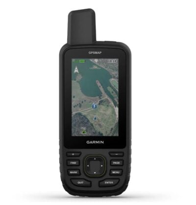
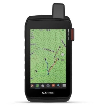
The Garmin GPSmap 66SR is a handheld GPS Receiver for hiking, climbing, geocaching, kayaking or mountain biking, explore more by using this premium, rugged handheld with a 3″ colour display, preloaded maps and multi-band frequency support providing you with the best possible positioning technology.
MAIN FEATURES:
- No squinting necessary with this large, sunlight-readable colour display.
- Multi-band technology and expanded GNSS satellite support guide the way in challenging locations.
- Let your loved ones follow your adventure with location tracking.
- Two-way messaging lets you share the moment with the ones who matter.
- Have an emergency? Trigger an interactive SOS alert anytime, globally.
- Maps as pretty as a picture and just as detailed — without a subscription.
- See the peaks and valleys clearly with TopoActive Europe maps.
- Having Active Weather is like having your own personal weather forecaster on every journey.
- Track your position in challenging conditions with multi-band technology and expanded GNSS support.
- Travel longer with up to 165 hours of battery life in tracking mode and up to 425 hours in expedition mode.
-
100% GLOBAL IRIDIUM® SATELLITE NETWORK
Instead of relying on mobile phone coverage, now your messages, SOS alerts and tracking are transferred via the global Iridium satellite network.
EXPANDED GNSS SUPPORT
Access multiple global navigation satellite systems (GPS, GLONASS, GALILEO and QZSS) to track in more challenging environments.
MULTI-BAND FREQUENCY SUPPORT
Receive and utilise multiple frequencies sent by navigation satellites which enable improved user position accuracy, specifically in areas where GNSS signals are reflected, weak or typically do not penetrate. Get superior accuracy using state of the art technology, previously only available to the military.
ABC SENSORS
Navigate every trail with ABC sensors, including an altimeter for elevation data, barometer to monitor weather and 3-axis electronic compass.
BIRDSEYE SATELLITE IMAGERY
Download high-resolution photo-realistic maps directly to your device without an annual subscription. Easily find trails, pick stand locations, find parking, create waypoints and more.
PRELOADED TOPOACTIVE EUROPE MAPS
Preloaded TopoActive Europe maps show you summits, parks, coastlines, rivers, lakes and geographical points.
ACTIVE WEATHER
When paired with your compatible smartphone, you can get real-time forecast information and live weather radar, so you’re always aware of the surrounding conditions.
IN THE BOX:
- GPSMAP 67i
- USB cable
- Carabiner clip
- Documentation